6.7 Navigation, Orientation
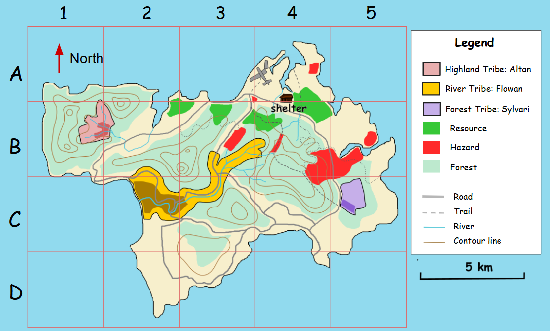
backAnswer the questions based on the map.

-
Questions:1
10Time left:01. Question
Identifying Hazardous Areas
What grid squares contain hazardous areas, as shown by the red zones on the map?
CorrectIncorrect -
Questions:2
10Time left:02. Question
Estimating Distance Using the Scale
The distance between the shelter (A4) and the hazardous area in B4 is roughly:
CorrectIncorrect -
Questions:3
10Time left:03. Question
Following Directions
If you start at the shelter (A4) and head south, which grid square will you reach?
CorrectIncorrect -
Questions:4
10Time left:0CorrectIncorrect -
Questions:5
10Time left:05. Question
Navigation by Landmarks
If you are traveling from C3 to B2, which feature is a good natural landmark to guide you?
CorrectIncorrect -
Questions:6
10Time left:06. Question
Safe Travel Route
What is the safest route from A4 (shelter) to C3 (Flowan territory), avoiding hazardous areas?
CorrectIncorrect -
Questions:7
10Time left:0CorrectIncorrect -
Questions:8
10Time left:08. Question
Estimating Travel Time
If walking 1 km takes 20 minutes, how long will it take to walk from the shelter (A4) to the tribe in C3?
CorrectIncorrect -
Questions:9
10Time left:0CorrectIncorrect -
Questions:10
10Time left:010. Question
Planning Shelter Expansion
If the group wants to expand their shelter into a nearby safe area with resources, which grid square is best?
CorrectIncorrect
Summary
0 of 10 questions completed
Questions:
Information
You have already completed the quiz before. Hence you can not start it again.
Quiz is loading…
You must sign in or sign up to start the quiz.
You have to pass the previous Module’s quiz in order to start this quiz:
Results
you have successfully completed the quiz.
Summary
You have passed the quiz.
Try your best next time.
Questionnaire
- 01
- 02
- 03
- 04
- 05
- 06
- 07
- 08
- 09
- 10
- Answered
- Review
