6.7 Navigation, Orientation
backUnderstand /6
6.7.3 Why Navigation Matters
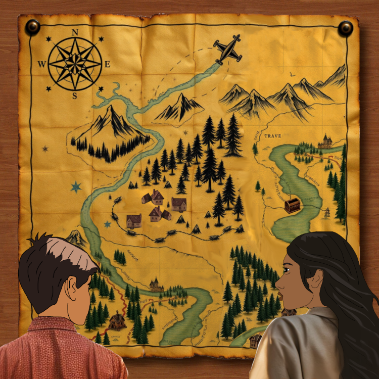
Asha was cleaning the attic when she found an old, dusty map.

This is a compass rose. It shows directions like north, south, east, and west. We’ll use it to orient the map and figure out where to go.
Here is a mountain range. Mountains are easy to spot in real life, and they can help us stay on track. On maps, they arre drawn with peaks and shading to show their height. We will use this as a landmark.
Look at this river winding across the map. Rivers are great for navigation, they often lead to settlements or important locations. If we get lost, we can follow the river.
This must be a treasure map. Look at that chest at the river. Sure there is gold in it. Let's find it.
First, we need to figure out where we are on this old map. But it’s tricky, this map is so old, and things change over time. Rivers can shift, forests can shrink, and villages can grow into towns. We’ll need to match the landmarks we see today, like the mountains, rivers, and forests, with what’s drawn on the map. Once we know where we are, we’ll be able to plan our way to the treasure.
This dashed line should show a trail. Trails are paths that guide us through forests or mountains. But why does it have an airplane on it?
Here is where the treasure is hidden, a chest. But getting there won’t be easy.
The trees on the map represent forests. They are important landmarks because they are easy to recognize and can help you stay on course by following their edges.
The small houses on the map mark villages. Even if the villages have changed over time, their locations can still guide us on our journey.

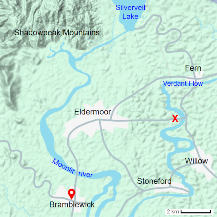
We are using Google Maps to find out where we are and where the treasure chest must be.
This spot is now a small park. Could the treasure still be buried under the grass?
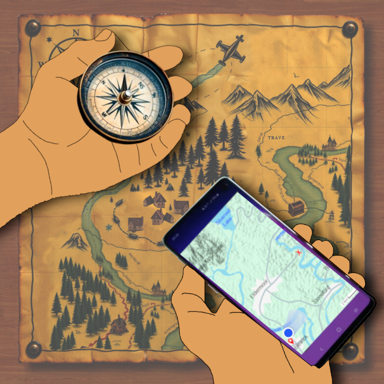
This is our village. I clicked on the location where our house is, which is why we see the red triangle with a hole. It is like a compass built into Google Maps, guiding us.
Look, the scale on Google Maps shows that this distance is 2 kilometers. By measuring the path from our house to the treasure, it seems to be around 10 to 12 kilometers away. That’s a good hike, but with the map and our tools, we’ll get there.
The Shadowpeak Mountains. They are still in the same place today and are now part of a popular hiking trail. On Google Maps, the mountains look smoother and are shown in lighter green with contour shading.
The dam formed the Silverveil lake.
There are more roads now than in the past. They are marked as grey lines on the Google map.
This area was marked as a thick forest on the old map. The forest still exists, but parts of it have been cleared for farming and new homes. On Google Maps, forests appear as green patches.
Here it is! The Moonlit river is still in the same spot, but now there’s a small dam upstream, which has slightly changed the flow.
Eldermoor is marked here as a small cluster of houses on the old map. On Google Maps, Eldermoor has grown into a bigger town with more roads and buildings.

"Hold the compass flat in your hand and turn until the needle points north. Then align the map to match the compass. This way, you’ll always know your direction".
"Ridiculous, we don't need this old tool. With our smartphone we always know where to go."
"Just in case. You never know. Unlike a smartphone, a compass never runs down. It will always guide you to the north."
Google Maps shows our location as a blue dot on the map. The dot moves as we move, so we can check if we’re on the right path.
Google Maps makes navigation even easier by letting us choose a starting point and a destination. Once we enter where we want to go, it calculates the best route and even guides us step by step. It will even tell us when to turn or follow a path.
GPS, or Global Positioning System, works by using satellites orbiting the Earth. These satellites constantly send signals to devices like our smartphone.
As we move, the GPS keeps updating our position by continuously communicating with satellites. This is why the blue dot moves along the map and adjusts the directions if we take a wrong turn.
GPS is like our invisible guide, helping us find our way, even when we’re far from home.

"Awww, the phone battery just died. How are we going to get home? Do you remember the way?"
"Not exactly, but I do remember this mountain was on our left side when we came. If we walk back, it should be on our right side."
"Not exactly, but I do remember this mountain was on our left side when we came. If we walk back, it should be on our right side."
"Where did you put the compass? We need it!"
"Uh... I left it at home. I thought it would be useless."
"Whaaaat?!"
"Sorry! You will have to come up with another way to navigate."
"You are right. There are plenty of ways to find our way. Look at the sun, it is setting. That shows us the direction of west."
"Uh... I left it at home. I thought it would be useless."
"Whaaaat?!"
"Sorry! You will have to come up with another way to navigate."
"You are right. There are plenty of ways to find our way. Look at the sun, it is setting. That shows us the direction of west."
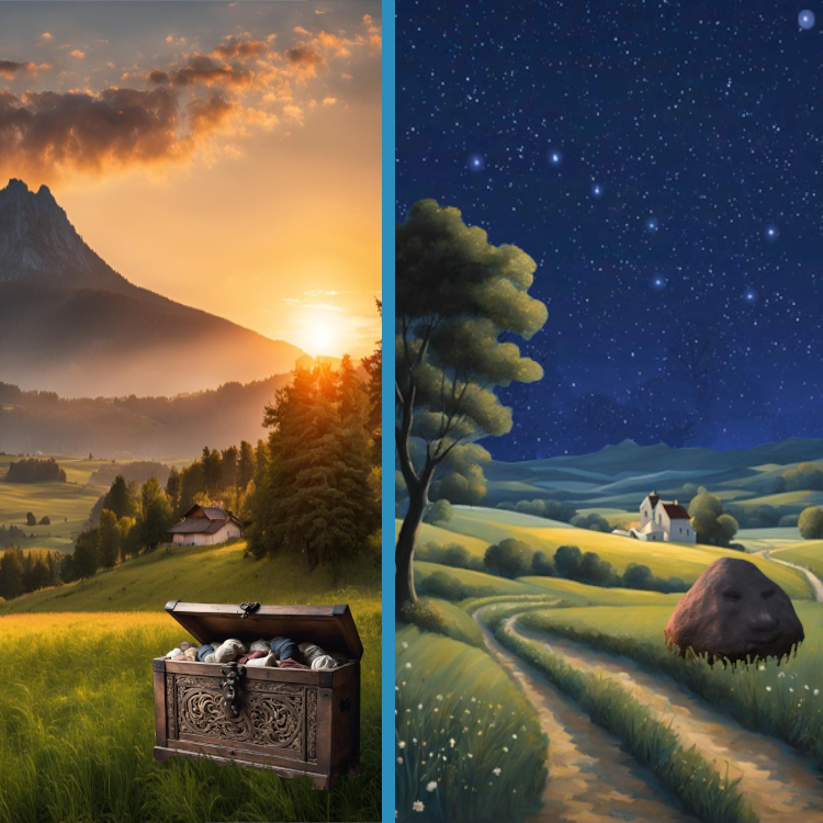
"After 3 hours of hiking is this our reward? A treasure chest full of old socks?"
"Never mind, look at the bright side, the chest is beautiful. I guess we can sell it for good money."
"Are we lost already? I don’t recognize this place."
"I do! We passed this weird rock shaped like a human face."
"Ah, right! Landmarks to the rescue, hehe..."
"I do! We passed this weird rock shaped like a human face."
"Ah, right! Landmarks to the rescue, hehe..."
"The sun’s already set, and we don’t have a compass. I think we might be heading northwest. Can you spot the North Star?"
"How do I find it?"
"Look for the Plough constellation. It is shaped like a ladle. See the two stars at the edge of its bowl? Extend an imaginary line upward from those two stars. The bright star you see is the North Star. It always points north."
"Got it! So, if that’s north, we should definitely turn south to get back home."
